"iPrimera Vía Láctea De 2021 1 "
"iPrimera Vía láctea de 2021 1 "
Seguimiento / apilado / mezclado
El autor de esta fotografía nos comparte su suerte de poder vivir a 20 minutos de una buena calidad de cielo. En el sur de Francia estan en un Bortle 5-4 para que puedan ver la Vía Láctea a simple vista.
Para esta imagen utilizo su nuevo filtro Halpha en su D800 Astrodon y aquí está el resultado.
Nikon D800 astrodon + Sigma 35mm Art & NISI filtro de luz natural.
Montura de seguimiento de Star Adventurer
Cielo: 10 Ha B 120 segundos F3.2 iso4000
8 RGB B 120 segundos F3.2 iso2000
FG: 120 segundos FI l iso iso800
Crédito: @anthonylp.photography
Facebook: Anthony LP Photography

More Posts from Glaretum and Others
La vía láctea desde Bivacco Ferrario Grignetta, Italia.
Crédito: Erik Colombo
https://instagram.com/erikcolombophotographer
~Antares

Rocket Launches and Rising Seas
At NASA, we’re not immune to effects of climate change. The seas are rising at NASA coastal centers – the direct result of warming global temperatures caused by human activity. Several of our centers and facilities were built near the coast, where there aren’t as many neighbors, as a safety precaution. But now the tides have turned and as sea levels rise, these facilities are at greater risk of flooding and storms.

Global sea level is increasing every year by 3.3 millimeters, or just over an eighth of an inch, and the rate of rise is speeding up over time. The centers within range of rising waters are taking various approaches to protect against future damage.

Kennedy Space Center in Florida is the home of historic launchpad 39A, where Apollo astronauts first lifted off for their journey to the Moon. The launchpad is expected to flood periodically from now on.

Like Kennedy, Wallops Flight Facility on Wallops Island, Virginia has its launchpads and buildings within a few hundred feet of the Atlantic Ocean. Both locations have resorted to replenishing the beaches with sand as a natural barrier to the sea.

Native vegetation is planted to help hold the sand in place, but it needs to be replenished every few years.

At the Langley Research Center in Hampton, Virginia, instead of building up the ground, we’re hardening buildings and moving operations to less flood-prone elevations. The center is bounded by two rivers and the Chesapeake Bay.
The effects of sea level rise extend far beyond flooding during high tides. Higher seas can drive larger and more intense storm surges – the waves of water brought by tropical storms.

In 2017, Hurricane Harvey brought flooding to the astronaut training facility at Johnson Space Center in Houston, Texas. Now we have installed flood resistant doors, increased water intake systems, and raised guard shacks to prevent interruptions to operations, which include astronaut training and mission control.

Our only facility that sits below sea level already is Michoud Assembly Facility in New Orleans. Onsite pumping systems protected the 43-acre building, which has housed Saturn rockets and the Space Launch System, from Hurricane Katrina. Since then, we’ve reinforced the pumping system so it can now handle double the water capacity.

Ames Research Center in Silicon Valley is going one step farther and gradually relocating farther south and to several feet higher in elevation to avoid the rising waters of the San Francisco Bay.
Understanding how fast and where seas will rise is crucial to adapting our lives to our changing planet.

We have a long-standing history of tracking sea level rise, through satellites like the TOPEX-Poseidon and the Jason series, working alongside partner agencies from the United States and other countries.

We just launched the Sentinel-6 Michael Freilich satellite—a U.S.-European partnership—which will use electromagnetic signals bouncing off Earth’s surface to make some of the most accurate measurements of sea levels to date.
Make sure to follow us on Tumblr for your regular dose of space: http://nasa.tumblr.com.
Luna Llena
Crédito: Victor Soto
https://instagram.com/arquitrovo
https://www.facebook.com/Vitorsoto
~Antares

¿Qué está pasando en la nebulosa de la Estatua de la Libertad?
Se están formando y liberando estrellas brillantes y moléculas interesantes. La compleja nebulosa reside en la región de formación estelar llamada RCW 57. Se cree que los PAH se crean en el gas de enfriamiento de las regiones de formación de estrellas, y su desarrollo en la nebulosa de formación del Sol hace cinco mil millones de años puede haber sido un paso importante en el desarrollo de la vida en la Tierra. La imagen presentada fue tomada en el Observatorio Interamericano Cerro Tololo en Chile.
Créditos: S. Mazlin , J. Harvey , R. Gilbert y D. Verschatse
-Betelgeuse

¿Naciste después del 1 de noviembre del 2000?👶 ¡Eres de "Generation Station"! y has vivido toda tu vida con el @Space_Station orbitando por encima.
Ven y conoce a estos estudiantes que están contribuyendo a @ISS_Research en el laboratorio en órbita:
https://go.nasa.gov/31kE5Kl

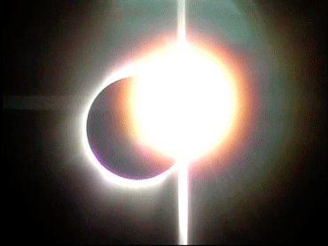
Eclipse Total Solar 2010
Crédito: Andreas Möller

Collage de capturas de estos últimos años.
Crédito: Astro Matt
https://twitter.com/astromatt75
~Antares

Via Láctea sobre Grosseto, Italia.
El autor nos relata que estuvo jugando con las luces para poder obtener el tipo de iluminación que el deseaba. Mientras hacía eso, el cielo se logró despejar para poder tomar captura de la Vía Láctea, ya que cuando llego al lugar, no era bueno el pronóstico. Para saber más detalles de la foto, los invitamos al perfil del autor en instagram.
Nikon D850 - Nikkor 20mm f1.8
Crédito: Pellegrini Stefano Photography
https://instagram.com/pels_photo
~Antares

¿Cómo empezó? ➡️ ¿Cómo va?
Las imágenes del Hubble de la Nebulosa Stingray tomadas con 20 años de diferencia muestran la forma cambiante de la nebulosa y una pérdida dramática de brillo.
📸 NASA, ESA, B. Balick (Universidad de Washington), M. Guerrero (Instituto de Astrofísica de Andalucía) y G. Ramos-Larios (Universidad de Guadalajara)
~Félicette


-
 redx-e reblogged this · 1 year ago
 -
 de4dbutprettysstuff reblogged this · 2 years ago
 -
 sputnik21x liked this · 4 years ago
 -
 cerulleann liked this · 4 years ago
 -
 me-gusta-la-soda-compartida liked this · 4 years ago
 -
 shadowsalone liked this · 4 years ago
 -
 interstellarsailor reblogged this · 4 years ago
 -
 concretenfells liked this · 4 years ago
 -
 glaretum reblogged this · 4 years ago

Glaretum fundado en el 2015 con el objetivo de divulgar la ciencia a través de la Astronomía hasta convertirnos en una fuente de conocimiento científico veraz siendo garantía de información seria y actualizada.
248 posts